The Arboricultural Consultants’ job of surveying trees, collecting data and preparing Tree Survey and BS 5837 reports is made more efficient and cost effective when using the OTISS website, maps and reporting facilities together with the OTISS mobile survey apps (Android phones and tablets).
Staff and clients can access from any where, at any time. READ MORE…
This video provides an overview of how Arboricultural Consultants would use OTISS to carry out a TreeSafety or BS5837 survey. Setting up the client survey; on-site surveying; checking the data; and producing some reports. There is no voice-over – just subtitles.
BS5837 Surveys
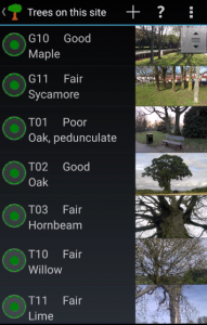
Complete BS5837:2012 survey form.
Automatic calculation of RPA. Modify RPA as required.
Take Photos as part of the Survey.
Good photos reduce the need for detailed descriptions, and speed up the survey process. Markup the photos with coloured lines and arrows.
The photos are considered to be an integral part of the survey and are sync’ed to the OTISS website along with the other survey data.
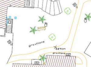
Maps & Drawings
Upload your site/topography plans, CAD drawings, Ordnance Survey Mastermap, PDFs and geo-referenced maps. Also available are: OpenStreetMap, Google Street and Aerial Maps.
Reports
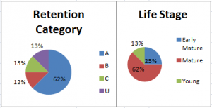
OTISS does not force you to use a particular report format. Instead we provide a set of customisable charts and data tables (PDF and Excel), maps and CAD; for you to encorporate into reports and work schedules.
Benefits of being ‘online’
Share maps, data and reports directly with your clients. Team surveying on large sites with your colleagues and sub-contractors. READ MORE…
Prices
OTISS is an online service, there is no software to install or maintain on your PCs. After the free trial, users pay an annual subscription for the use of the system. READ MORE…
Students & Colleges
Arboricultural students can use OTISS for free for coursework and study. READ MORE…
Android or iPhone
The OTISS survey apps run on all Android phones, tablets and GPS devices. You can also use an Android tablet linked via your iPhone for on-site surveying. READ MORE…